DEEP WELL PERMITS INCREASE IN CALHOUN - Is The Boom A Reality?
The deep well boom has finally reached Calhoun County, nearly thirty years after an exploratory well was drilled at Mt. Zion. The string of permits stretch across the Trenton - Black River formations of the Appalachian Basin. (SEE pictures, map and earlier deep well permits under ARCHIVES March 11, 2001)
Ground has been broken for the first deep well site in Calhoun at the head of Bull River near the White Pine Road.
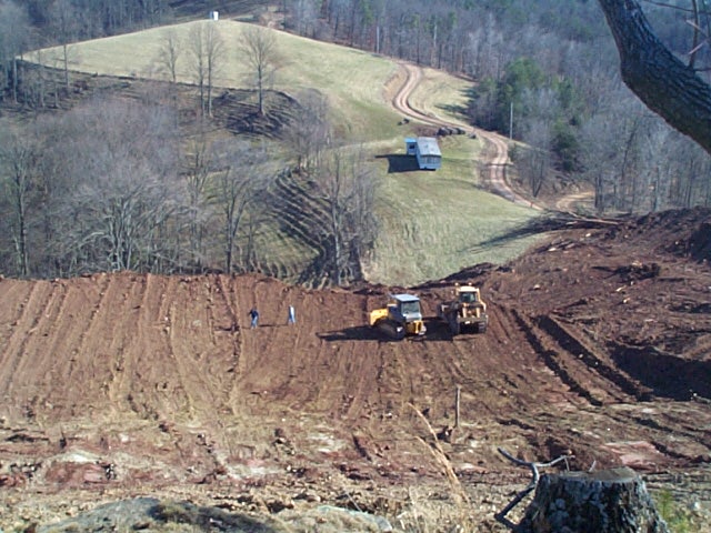
Well site at the head of Bull River
On March 2, 2001 the Baker Hughes Rotary Rig Count for West Virginia showed 21 in operation, with a limited number of rigs able to do deep well drilling.
The results proclaimed are beyond "wildest expectations," based on the production of deep wells in Roane County. The deep wells are apparently producing millions of dollars in sales, with well pressures at 5000 pounds. A regular shallow well often has 700 pounds pressure.
Recent additional well permits in Calhoun:
Mace lease (Mace #2) 49.5 acres on Sinking Springs Run, surface owner Delores G. Mace, royalty P. P. Gunn heirs, well operator Steven Satterfield Production, Grantsville, estimated depth 10,000 feet (12/13/2000).
Crawford lease (Crawford #2) 50 acres on tributary of Sinking Springs Run, surface owner Gerson Woodlands, royalty Randy Umstead et al, well operator Steven Satterfield Production, Grantsville, estimated depth 10,000 feet (12/13/2000).
Laughlin surface, 61.88 acres on Mushroom Run of the West Fork, Little Kanawha River, Lee District, surface owner Michael Laughlin, royalty Hays heirs, well operator Ardent resources, Bethel Park PA, estimated depth 22,000 feet (11/6/2000).
Victor #1, 75.25 acres on Road Fork of Laurel Creek, Sherman District, surface owner Trio Petroleum, royalty owner Lorentz Hamilton et al, well operator Trio Petroleum, Glenville, estimated depth 21,000 feet (1/24/2001).
Shock surface, 112 acre lease at Mt. Zion, Center District, waters of Phillips Run, surface owner Mark Shock, royalty C. L. Shock, well operator McIntosh Partnerships, Arnoldsburg, estimated depth 14,000 feet (12/12/2000).
Kesler Unit (J. M. Smith #1), 81 acres on Big Run, Sherman district, surface owner Orville Yoak, royalty owner Kesler, Burrows and Yoak unit, well operator Trio Petroleum, Glenville, estimated depth 21,000 feet (1/23/01).
Barr-Cabot Lease (J. M. Smith #2), 324 acres on Phillips Run watershed of Center District, surface owner Mac Barr heirs and David Barr, royalty owner McCellan Barr heirs, well operator Cabot Oil and Gas, Charleston , estimated depth 21,000 feet (10/31/2000).
Stump-Cabot Lease (J. M. Smith #1), 157 acres on Little Kanawha River of Center District, Georgia Stump surface owner, Georgia Stump et al royalty owner, well operator Cabot Oil and Gas, Charleston, estimated depth 21,000 (10/30/2000).
Craddock surface, 68 acres on Daniels Run of Lee District, surface owner Forrest Craddock, royalty owner W. T. Wiant estate, well operator Ardent Resources, Bethel Park PA, estimated depth 22,000 feet.