|
|
|||


|
|
|
||||||||||||||||||||||
|
|
|||||||||||||||||||||
|
|
|||||||||||||||||||||
|
||||||||||||||||||||||
 |
PUBLIC MEETING SATURDAY FOR CALHOUN LANDOWNERS AFFECTED BY PATH POWER PROJECT |
| (11/21/2009) |
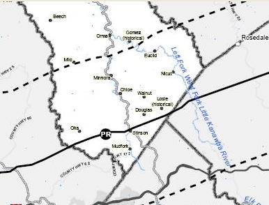
Giant power line map of southern Calhoun shows the black
The Potomac-Appalachian Transmission Highline (PATH) Calhoun County land owners affected by the PATH power line crossing the southern part of the county, are invited to attend a public meeting this Saturday at 1 p.m. at the Upper West Fork Park at Chloe. The purpose of this meeting is to provide Calhoun land owners with an explanation of power company tactics concerning surveying agreements, right of way options and condemnation lawsuits. View the WV Public TV segment on PATH here
|
|
|