|
|
|||


|
|
|
||||||||||||||||||||||
|
|
|||||||||||||||||||||
|
|
|||||||||||||||||||||
|
||||||||||||||||||||||
 |
THE WORST RATED BRIDGES NEAR YOU - Calhoun, Roane, Gilmer, Wirt, Braxton, Clay, Ritchie |
| (08/08/2006) |
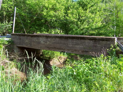
| By Bob Weaver West Virginia is a state where every bridge has a safety rating. Weight limits have been enforced on most of them, except if it's an overweight truck owned by a coal company, which has now been legalized. Replacing or repairing the states bridges to bring them up to standard is said to cost lots of money, maybe billions. The West Virginia Department of Transportation has provided the Herald with a list of bridge ratings for seven regional counties, obtained through a *Freedom of Information request. The rating formula is a National Bridge Inventory model, and takes into account a number of parameters for each bridge, according to Clifford W. Essig, District 3 Engineer in Parkersburg. The scale is from zero to 100, with 100 indicating the bridge is in perfect condition. Bridges have been given a "sufficiency rating" which uses three elements. Fifty-five percent of the rating is structural adequacy, thirty-percent is serviceability and fifteen percent is related to public use, or how many and what type of users. Bridges that have a span less than 20 feet are considered short spans and are handled through the county. Most of those bridges are crossed each day by trucks exceeding their weight limit. CALHOUN When the Herald last did a list of bridges in 2003, the Annamoriah Run bridge (Route 35) just off State Route 5 was among the worst with a rating of 21.3868. It has now been replaced, among several others. The worst Calhoun bridge on the current list is the Apple Farm Bridge on Steer Creek, built in 1915, with a rating of 21.2872.
Egypt Ridge-Rocksdale bridge (1889) over the
The Barnes Run bridge, at the mouth of Barnes Run where it While the bridge is officially not in Calhoun, but is used by Calhoun residents, the Rocksdale Bridge (1889) that accesses Egypt Ridge to Spencer has one of the worst ratings at 18.6813. Residents of the lower West Fork, Barnes Run, Hur, Rowels Run, access Spencer by the Rocksdale Bridge (1889), whose rating is very poor. The only other short cut is the low-water bridge at the mouth of Henry's Fork, frequently closed because of water. Other bridges that appear to have some problems in Calhoun are in the 50 to 60 range:
- Henrietta Bridge/Laurel Creek (1940) Route 5 - 48.4521 BRAXTON COUNTY
- Burnsville T-Beam (1929) Oil Creek - 41.5232 CLAY COUNTY
- West Porter Creek (1926) Porter Creek - 25.0000 GILMER COUNTY
- Indian Fork Truss (1910) Sand Fork - 22.0322 ROANE COUNTY
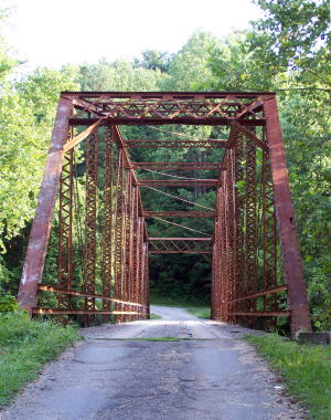
- Wellington Double Arch (1920) Spring Creek - 15.4100 RITCHIE COUNTY
- Hushers Run Road Arch (1915) Bonds Creek - 23.9292 WIRT COUNTY - Spring Creek Truss (1889) Spring Creek - 16.8525 * It was difficult to obtain the bridge ratings, which should be readily available public information, and was once freely accessed from the bridge engineer in charge of the district, but in this instance required a Freedom of Information request to Charleston.
|
|
|